The Gulch, the railroads and the start of Atlanta
Sakshi Nanda | November 4, 2024
[Note from the editor: because Sakshi wrote this (wonderful) guest post before construction began on Centennial Yards, the references to an “empty” Gulch end up being a thoughtful reflection on our experiences with the place during its long existence as a mass of parking lots; it was a significant period which informed our evolving relationship with this part of Downtown Atlanta. Food for thought: what kind of historical markers could be added to Centennial Yards to help people understand the history of this space within Atlanta’s evolution?]
Sakshi’s Contextual Montage for the Gulch
Biosketch, author: Sakshi Nanda
Sakshi Nanda is an Urban Designer and Indian Architect passionate about the confluence of history, architecture, and urban landscapes shaped by her experiences and learnings in India and the United States. Sakshi holds a Bachelor of Architecture from University of Mumbai and is a licensed architect in India. Her thesis was based on documenting historic buildings and creating a temporal event space along a street in her home city. Further, she earned Master of Science in Urban Design from Georgia Institute of Technology, where she worked on urban design studios as well as pursued her own research of the railroad history of Atlanta and the evolution of urban form. Memory, history, and urbanism have been a common theme in her career throughout and she aspires to build more to it. Presently, she works at ZGF Architects in Portland, Oregon on significant master planning and transit projects with rich history and connection to community.
The Gulch served as a parking lot for the neighboring avenues. Photo credit: Sakshi Nanda
Faint lines of rail tracks were under the asphalt. Photo credit: Sakshi Nanda
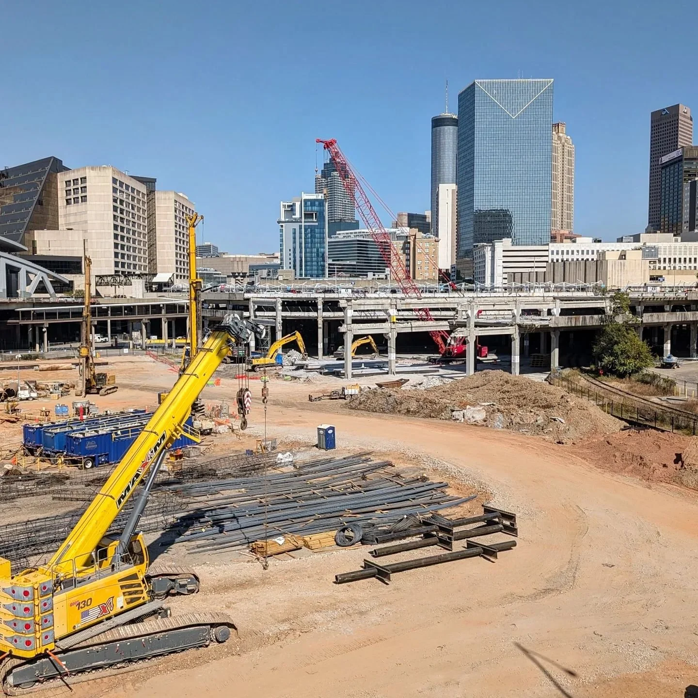
Currently, much of the Gulch is a construction site for the Centennial Yards development. Photo credit: Darin Givens
Cities are planned around varied landscapes, be it water, parks, or the street network. The City of Atlanta’s formal organization is characterized by a special, central place known as the Gulch: a triangular, vacant, underutilized, and unnoticed space in the heart of downtown. The site was also known as The Terminus, a significant intersection of the Western and Atlantic railroad lines. The confluence of railroads determined the form of the city. Currently a vacant forty-acre land, it is the talk of the town for massive redevelopment proposals.
Site with the context of Downtown Atlanta
“Atlanta is not a city it is a landscape.” To understand Atlanta’s landscape one must look at the starting point. The Gulch, which was an intersection of railroads, has a significant role in defining the landscape of Atlanta.
In the United States, the first railroads appeared in the 1830s and brought a new dimension to trade connectivity and city planning. The network grew strong along the east coast connecting New York, Jersey, Washington, Philadelphia, Carolinas, and Georgia. Railroad towns boomed from 1850 to 1910; these towns became an integral part of the beginning of urban settlements in different states across the country. Chicago, New York City, Baltimore, Denver, Portland, Pittsburgh, Chattanooga, Atlanta, and Sacramento are significant examples that have emerged due to railroads. It is vital to understand the morphology and expansion of the railroad towns as they have molded today’s city centers. Following the railroads industrial development followed, making the city an important nexus of the Southeast.
The city rose from the ashes following the Civil War. It grew at different times, expanded to its suburbs, and is the birthplace of many revolutionaries and enterprises today. A significant railroad town of the south, the city was shaped by the people, the railroads, the industries, and then- the car-centric development. However, one thing that remains unchanged over the years is the Railroad Gulch near the Downtown. This is the start of today’s major city-Atlanta—a noteworthy confluence of railroads, watersheds, and now the busy streets. A place that is more than a parking lot after a concert or a game, it transforms into a place for celebration temporarily.
The Gulch. Photo credit: Sakshi Nanda
Since the roads were built over the site and railroads the focus shifted to the commercial development and stadium infrastructure but not the site. Infrastructure developments continued to happen over the grade and left a void. Keeping the memory and journey of this site alive can contribute to a crucial intangible heritage for the future. Urban voids are a part of our cities, and a reminder of events, nostalgia, deterioration, and identity. The void needs to be addressed not only in conjunction with the surrounding built but also through the inactive elements that have lost a sense of identity today.
Drone view of the site indicating the marks of old railroad tracks. Photo credit: Phillip Jones
The Gulch. Photo credit: Sakshi Nanda
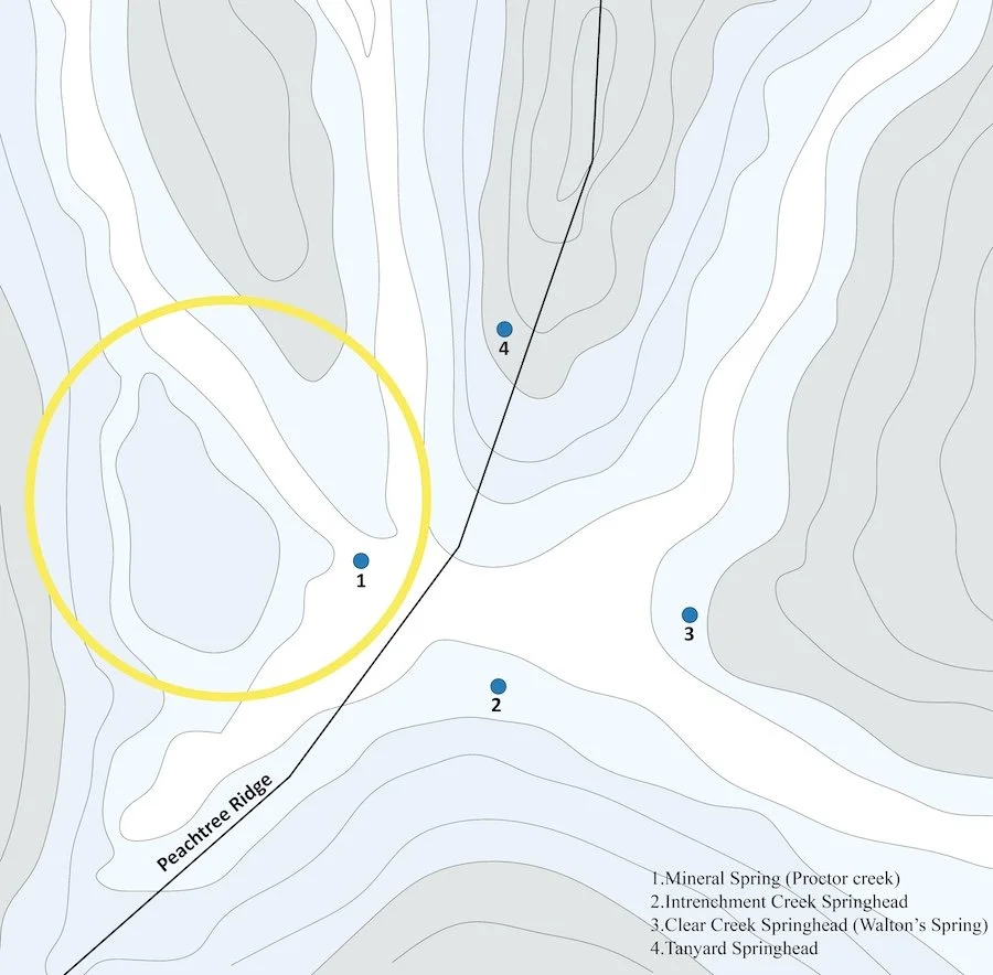
Site topography and relation to the historic springheads, Sakshi Nanda
Atlanta is located on the southern slope of the Appalachian, Piedmont. The Peachtree Ridge is significant from the topographical perspective as it resulted from the folding of substrata. The site was selected near the Mineral Spring, a flattened area (encircled in the image above). This spring is the start of Proctor Creek, which connects to the Chattahoochee River. The history of different springheads suggests a direct relation to the active creeks of the 1700s. This suggests that the indigenous tribes resided near a watershed; it may have been a major source of travel and transportation.
Railroads, major streets and Zero-Mile Post, 1847, Sakshi Nanda
The city was founded at the intersection of three railroads. Stephen Harriman Long chose the site along Peachtree Ridge, which was known as the Terminus. In 1839, a Zero-Mile post marked the southeastern end of the Western and Atlantic Railroad connecting Chattanooga. The one-mile radius that grew from the marker is the start of Atlanta.
Rail expansion around the Terminus, Sakshi Nanda
The Terminus which was supposed to be the last point of railroads coming to the south, expanded and created a network in Georgia. There was a rise of railroad towns in Georgia like Valdosta, Athens, Waycross, Lavonia, Forsyth, Augusta, Roswell, and Decatur. Although there is a decrease in rail travel, even today Georgia has the largest rail network in the southeast. The location connects the Mid-Atlantic, Northeast, and Midwest regions of the United States.
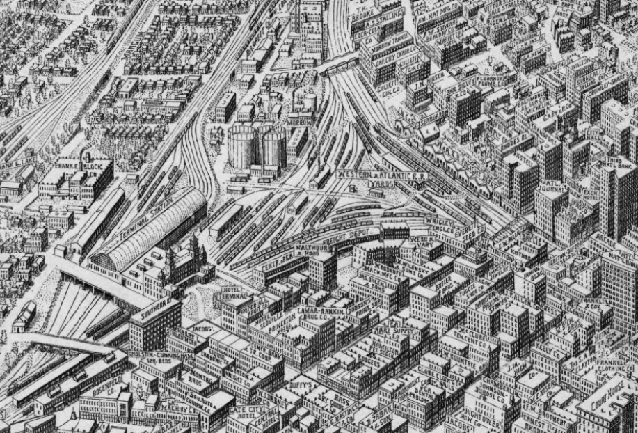
Library of Congress 1919
1864 Battle of Atlanta, Library of Congress
The superimposition of Vincent’s Plan, the Proctor Creek, Railroad lines, the battles of 1864, and the earthworks and batteries in a 2-mile radius around the Gulch show how eminent the site was. When one walks near the site there is no historical marker that states about the story of how this void holds the city. Soon there will be an on-fill development where the city will lose the void and Atlanta’s story will be buried.
Special thanks to Dr. Danielle Willkens, Jeffrey Morrison and Hannah Palmer for supporting me during the research and sharing valuable insights.


